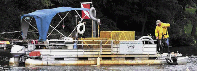
Photo 1: Lake Arrowhead's Suction Dredge
The Third McWain Pond Plant Survey Earl Morse
(An update to the First Survey Article, included below)
On July 30, 2014, a group of dedicated volunteers threw themselves into the water of McWain Pond to hunt for good guys and bad guys, plant-wise at least. It was our third summer foray into the deep to enrich our understanding of the “Who dat” of our pond's macro veggie community. In our lexicon, the “good guys” are native plants and the bad guys are the “invasives”; the most common invasives around here being Variable Milfoil, Eurasian Milfoil, and Hydrilla. The good news was that we enriched our inventory of native plants, examined about 75% of our shoreline, and found NO invasives!
I understand the impact that invasives have on the recreational opportunities of our lakes. For example, Candlewood Lake, a once pristine western Connecticut recreational resource, has been overwhelmed by Eurasian Milfoil, Curly Leaf Pondweed, and Brittle Waternymph. Candlewood was where I was trained in SCUBA during my stint with the state DEP. At that time, I could see about 30 ft in any direction. Now, you can only swim there if you hire divers annually to clear your shoreline. See Photo 2, below, for an example of how obstructive invasives can be, in this case on Winnipesaukee. This area is now clear again because the town of Moultonborough annually hires a suction dredge and divers to keep the town dock area clear. It ain't cheap. The price of failure is too great.
Now here's the best part. I've been whining about getting more eyes on the water each year. This year we hit the jackpot and had a significant increase in swimmers in addition to our small group of “regulars.” Birch Rock Camp, the world's best summer adventure for boys, volunteered to become an annual participant. Not only did they provide space in their boathouse to operate our identification lab, their large group of campers and staff scoured about 50% of our shoreline. They were an impressive lot, bringing in more than 40 good samples. Thank you to Rich Deering and BRC for providing the McWain Pond Association with a location to conduct our survey and the camper power to get a job well done. Commitment to cooperation and environmental stewardship were also in great supply from
the Whichard family, Brian Smith and crew, Shane Sullivan and son, and the Hangers. While our turnout this year was outstanding, I know that next year will be even better.
I have updated the plant photos and inventory spreadsheet on our Mc Pond website at
http://www.mcwainpond.org/?page_id=8
In most cases, there are multiple photos of each species to help in your ID efforts. In addition, the spreadsheet has links to additional resources for everything we've found. The 2-page guide to invasives is also there. We are one of the few lakes in the area without any plant or significant animal invasives. We need to work together to keep it that way.
The First McWain Pond Plant Survey Earl Morse
The question of whether we have any invasive species in our pond has always been a nagging issue. In similar Maine ponds an invasive species establishment can be persistent and painful. The Lake Arrowhead Conservation Council, for example, has just completed building its second suction harvester boat. Each cost $55,000. It takes three to four people to operate a boat: a pilot, a plant organizer/mechanical specialist, and two scuba divers at $25 per hour each. Sadly, with both dredges in operation all they can do is keep boating channels in Lake Arrowhead clear. They don't have time to clear shoreline or private beaches. By the way, one Lake Arrowhead boat was leased to the Messalonskii Lake Association (photo 1) at the end of the summer season for a couple of weeks of harvesting for a $5,000 fee (boat only, no crew). Ouch!
Photo
1: Lake Arrowhead's Suction Dredge
In Maine the exotic milfoils and hydrilla are the most oppressive invasive aquatic plants, often blocking shoreline to depths of 18-20 feet. The picture below (photo 2) is from a steamboat meet I attend in September each year at Lake Winnipesaukee, NH. When I first attended this meet about 15 years ago this cove had a sandy bottom that was visible throughout. The next picture shows a boat docked in about 8 feet of water. The milfoil comes to within 10 inches of the water surface and extends from shore to shore in the cove. Few boats get to the channel under power since the plants quickly foul the props. Needless to say, it is nearly impossible to swim in this tangle of growth.
Photo
2 : Invasive milfoil on Lake Winnipesaukee
Invasive milfoils are established in ponds all around us: in the Songo River, Cushman Pond, Thompson Lake, Hogan Pond, Brandy Pond, Sebago, and Little Sebago. The plants have the full attention of the LEA and their respective Lake Associations. Each year scores of their volunteers and interns attempt to manage the problem in their afflicted lakes. One thing is certain -- the discovery of invasives kicks any lake association into high gear as recreational opportunities and property values quickly diminish. The state provides some assistance through the funds collected when all Maine powerboat owners annually register their crafts. State funding is seriously inadequate to handle the problem and, consequently, the state now requires all out of state registered power boats to pay their share by purchasing a milfoil sticker. These can be purchased at the Waterford town Hall for a cost of $20. Fewer than 12 were sold to out of state registered boat owners last year. Please help fund invasive control projects by purchasing these stickers.
Exotic invasive plants are nearly always spread to lakes by boats and trailers. Our pond has no inspection process and so we depend on boat owners to carefully inspecting their craft before entering and upon leaving our pond, or any local pond. This is a game of roulette, with the lake and shoreland residents as the prime losers. We will eventually be invaded and may be able to contain an infestation if we are vigilant enough. We need your help.
Currently, we have no trained active lake monitors. While the Volunteer Lake Monitoring Program offered an invasives monitoring workshop at the Wilkins house last summer, there were no McWain Pond Association members trained. There are presently very few eyes on the water at McWain Pond.
This year the LEA notified their client lake associations that they had summer interns available in Early September to help determine whether a lake was affected. The fee was modest and it was estimated that the process would take about two days. The issue was discussed by the board and it was decided that we use this opportunity to go a step further, that is to not only determine whether or not any invasives were present, but to conduct an inventory of all native plants growing in the lake. We figured that we could use our own volunteers to supplement the LEA interns and get a decent plant baseline. Since invasives displace native plants via competition, part of any control and restoration program attempts to monitor the reestablishment of a pond's native species. A plant baseline is a good idea, especially if it can be done at no added cost to the LEA survey.
Fortunately, the Whichard family, Arlene, Jared, and Bruce, quickly volunteered to help in the process. Bruce and Jared would be our in-the-water snorkelers supplementing the LEA interns Christian and Tyler Oren; Arlene would pilot her boat and provide GPS positions and a mobile sample processing station; and I would organize the samples and data and identify, log and photograph the specimens during and after the collection day. I also summarized the findings.
Here's how the process worked:
The lake shore was traversed in a counter-clockwise direction starting at the Whichard dock. This rotation direction was chosen since the north end of the lake has more plant diversity, greater light exposure, and being shallow and silty, a more conducive bottom for plant growth. The boat would be anchored at a series of sites where patches of submerged plants were clearly visible. A GPS position was taken and the site numbered sequentially. The divers would remain in the water between anchorages and swim the shore to depths of 15 feet, collecting exemplary samples and returning them to the boat. This swimming back and forth was an exhausting process in the cool September water. Once on the boat each sample was cataloged and packaged for later identification. If the LEA interns felt they recognized the plants, the sample was given a tentative common name. This common name and the GPS coordinates were placed in the collection bag along with the sample. Over the course of the day the divers swam back and forth to the boat, totaling miles of swimming effort. In spite of their fine physical condition and the use of wetsuits, the diving process was cold and exhausting. Wet suits were a necessity. As we navigated the shoreline the plant diversity and the discovery of new species decreased. By the end of the day we had collected samples (Photo 3) from around the entire pond, stopping at 29 anchorages (Photo 4). The south-west shores of the pond contained few new species of patches of vegetation and, consequently, there were few collection sites along this border.

Photo 3: A sample from site 2: aquatic moss, species unknown? Clearly a non-vascular plant
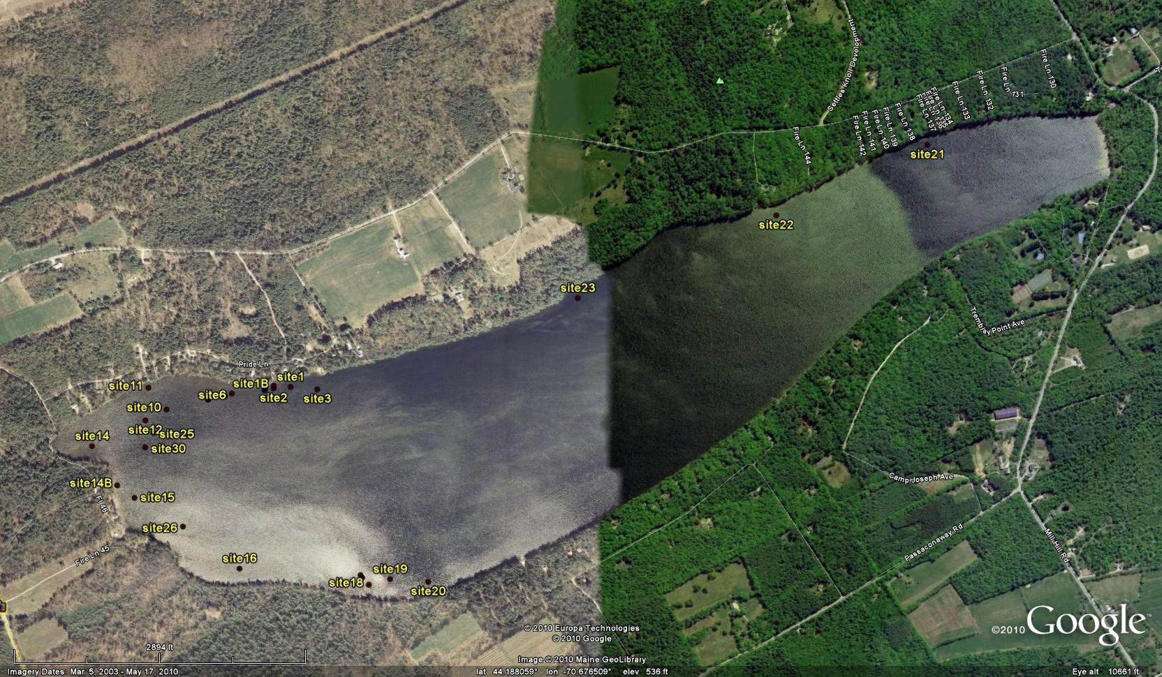
Photo 4: Google Earth photo of lake showing sampling sites (available on website in greater detail)
I then returned the samples to our home where, over the next 3 days, they were photographed, closely examined and given a tentative identification. Those of you who love wildflowers know that plants are most easily identified when they are flowering. An overwhelming number of aquatic plants don't flower till early fall. While there are exceptions like the water lillies, pipewort, and pickerel weed, the prime collecting season does not coincide with prime swimming season. A couple of samples like the rush and aquatic moss were not identifiable at the time of collection. About the only good sampling news is that most aquatic invasives have sufficient distinguishing leaf characteristics to make them identifiable nearly all growing season.
A few samples were not of sufficient quality and so a few days later Bruce, Arlene, Jared and I returned to Arlene's boat and re-visited those few GPS stations and found better samples. The LEA interns had only been used for day one to keep the costs down. The water was a tad cooler, but Bruce and Jared did not complain. Perhaps hypothermia had stilled their lips! Over the next few days the new samples were processed and photos of problematic specimens sent to VLMP for ID confirmation by their staff. At present we have to consider nearly all of our sample ID's as “tentative” since they were not flowering or not based on repeated sampling. With your help we will get a more definitive data base over the next few years.
The McWain Pond website will have the following results of our baseline survey:
A photo collection of all decent specimens, most not flowering (and, hence, not confirmed). All are captioned with the tentative common name anchorage site where tagged.
Download A spreadsheet showing the sample site location (latitude and longitude), tentative ID (common and botanic names) and a link within the spreadsheet to web-based additional information for that specimen.
A Google earth site locator for McWain Pond showing site locations (shown above in small detail).
A visit to the McWain Pond website ( http://www.mcwainpond.org ) will allow you to explore the photos and spreadsheet and link to external sites with more information about individual species found in our pond. The spreadsheet will be updated annually as we acquire more information from volunteers.
With a little effort on our members' part we will eventually have a larger monitoring effort, a few VLMP trained monitors, more eyes on the water, and far more milfoil stickers on our out-of-state boats. The whole trick in invasives management is to find the invaders quickly and remove them. Your help in keeping invasive species out of McWain Pond is greatly appreciated. If you would like to be trained as a monitor call VLMP at 207 783 7733 or visit VLMP at: http://www.mainevolunteerlakemonitors.org
and attend one of their training sessions.
Thank you, Arlene, Bruce and Jared for your many hours of work on our behalf.